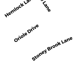
4 ORIOLE DR
Owner Information
BERTONI TODD J
4 ORIOLE DR
MILFORD, MA 01757


Property Details
4 ORIOLE DR is classified as a Single Family Residential (Split ent).
The primary structure on this property was built in 1966. There are 2,155ft2 of built area within this property. There is 2,155ft2 of residential/living space within this property. This property is listed as having 6 rooms.
4 ORIOLE DR is valued at $325,500. The land is valued at $136,300 and the structures are valued at $188,600. There is an additional valuation of $600 on this property.
This property is in Zone RB. Confirm with local Zoning Board authorities to ensure there are no overlays or other easements on this property.
The most recent deed for 4 ORIOLE DR is recorded at the local registrar in Book 52760, Page 69. 4 ORIOLE DR was last sold on Thursday, September 4, 2014 for $254,000.
Assessment data from fiscal year 2022.
Flood Data
According to the FEMA National Flood Hazard Layer, this property does not appear to be in a flood zone. It may also be in an area not yet reviewed. Nonetheless, confirm this information prior to taking any action.
To view the flood hazards around this property, create a FEMA "Firmette" Map of the area around 4 ORIOLE DR.
Broadband Internet Providers
| Provider | Type | Bandwidth (mbps) | |
|---|---|---|---|
| Verizon New England Inc. | DSL | 1 | 0 |
| Viasat Inc | Satellite | 100 | 3 |
| Verizon New England Inc. | Fiber | 940 | 880 |
| Comcast | Cable | 1000 | 35 |
| GCI Communication Corp. | Satellite | 0 | 0 |
| HughesNet | Satellite | 25 | 3 |
| VSAT Systems, LLC. | Satellite | 2 | 1 |
Broadband service provider data from December 2020.
Adjacent Properties
- 5 STONYBROOK LN
Single Family Residential owned by DONAHUE DONALD E JR - 7 STONYBROOK LN
Single Family Residential owned by SUSSMAN CARLETON L - 9 STONYBROOK LN
Single Family Residential owned by CORNELIA JAMES & SUZANNE P TRU - 6 ORIOLE DR
Single Family Residential owned by CURLEY ERIN P - 2 ORIOLE DR
Single Family Residential owned by PATERNO MICHAEL A